Sea of Cortez
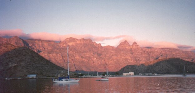
Sunrise at Puerto Escondido
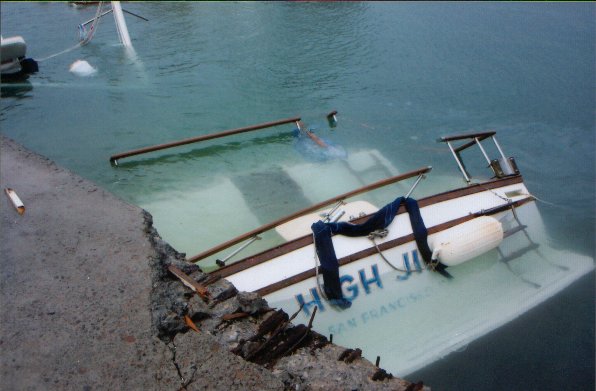
Welcome to Jinx and Mad Dog’s Sea of Cortez homepage. We have cruised Mexico’s beautiful Sea of Cortez for over twenty years now, even after we lost the original High Jinx to Hurricane Marty. Undaunted, we have a new High Jinx are back on the water, enjoying Mexico’s great cruising grounds. We want to share with you the good, the bad and the downright ugly side of cruising in Mexico. We are somewhat partial to the Baja side of the Sea, but have found much to like on the mainland side.
The Sonrisa Ham Radio Net now has its own web site. http://sonrisanet.org
Most cruisers and many Baja visitors listen to the weather on the Sunrise Net (3.968Mhz) every morning. The net has, over the years, become the definitive source for
current weather for the Sea of Cortez and the Mexican Riviera and now that Baja Geary has taken over the weather, cruising has become safer. He’ll be the first to say he is sometimes wrong. but when he says head for port, you had best do so! For the Baja visitor, afternoon sailor, or a full-time cruiser on Mexico’s Pacific coast and the Sea of Cortex, this is your go-to destination.
Stuff You Gotta Have Before You Cruise to Mexico
Jinx’s boating adventure books are priced to please (Kindle .99 to 2.99) here
 Mexico Boating Guide and it is a doozy. Anyone heading south this year needs this cruising guide. The 2nd edition covers Baja, the Sea of Cortez & Pacific Coast of Mexico – it does not cover the Gulf Coast & Yucatan Channel. Hurricanes Stan & Wilma in 2005 changed many reefs and soundings, so rather than publish inaccurate info, Pat and John deleted those chapters. That allowed them to include more details all around Baja, the Sea of Cortez & Pacific Mexico – which many boaters had requested anyway.
Not only is the 2nd edition expanded to 430 pages, it’s gonna be in glossy 4-color throughout! We’re so excited! All 350 photos and 250 GPS-accurate charts are in full color, even Satellite images in 4-color! Responding to readers’ requests, we added many Overall Planning charts to the regular anchorage charts. Our new “Paperwork Two Step” chapter has all the new rules plus blanks of the new Crew List form for international
arrival. And we added a handy “Resource Guide” chapter for quick reference (email, websites, tel-fax) to all marinas, fuel docks, boat yards, chandlers, ships agents, air & land transportation, emergency services, etc. We did the “Resource Guide” in the 5th edition of our other nautical guidebook, Cruising Ports: Florida to California via Panama, and cruisers asked us to add it for the new Mexico Boating Guide too. So, we did. We’re going for the whole enchilada!
And Now, After That Commercial Break, Back to the Sea of Cortez
About Us: Making a Boat “Cruiser Friendly”
We are powerboaters, with one boat sunk by Hurricane Marty. The second High Jinx is now in her slip in Santa Rosalia, getting “un-powerboated” in small steps. On the old High Jinx, a 42′ trawler, we cruised in “sailboat” mode: we favored anchoring out to marinas, tended to move at around five knots, and didn’t even have an icemaker! We also had “un-power-boated” our powerboat so it was better suited to living aboard in the Sea. We converted to propane refrigeration and cooking, added solar panels, an inverter and extra house batteries so we were not slaves to our generator. Diesel fuel (and generator parts) are both expensive and hard to come by in the central Sea of Cortez (where we generally hang out) so we simplifed our lives with these conversions. As powerboat cruisers, we are outnumbered 50-1 by sailboats, but are convinced that no matter what vessel you have, the Sea of Cortez–that’s the Gulf of California to you gringos–is the ideal body of water for those seeking solace, the wonders of nature, and experiencing just enough excitement to remind us we are not living a “normal” life. Now we get to convert our new boat, a go-fast Sea Ray, into a cruising boat. Sigh.
We are ham operators (Mad Dog is WD6AWR and Jinx is KC6YMJ), and strongly believe that cruising the Sea of Cortez without benefit of marine sideband or ham radio is sheer folly. Even with banda ancha (broadband) from TelCel now widely available, the 4G is sometimes like 2G and simply not available everywhere. Don’t rely on cell phones alone…get that ham radio.
The purpose of this website is to avail you to our experiences in the Sea, whether you are a full-time cruiser, wanna-be-full-time cruiser, land cruiser, or armchair cruiser. If you have questions or comments just email us
Cruise News: The Good, The Bad and the Downright Ugly
La Paz: We will be visiting there this winter and will give a full update.
Punta Chivato: Sadly, the little store is no more. The good new though, is there is a restaurant, Los Chibatos, that is a cheaper alternative to the very pricey (but beautiful) hotel. The locals monitor VHF 72.
Puerto Escondido: What can I say? Fonatur has taken over everything, charging for everything. Gone is the sleepy Hidden Port, or anything at all free. However, now there is a fuel dock, a great restaurant, and a boat yard. As always, progress comes with a price. For updates click here. Hidden Port Yacht Club site
Santa Rosalia: We’ve been there for two years, and as everything else in Mexico, once you really like a place, they change everything. Fonatur once again made a decision (usually a bad one) to make all their marinas the same price, so expect cruisers to pay the same in Santa Rosalia as La Paz. I predict a fairly empty marina in the future. On the upside, you can now buy expensive diesel and gas at their Pemex fuel dock.
San Carlos: We hear that Marina Real has gone downhill, but will see for ourselves in December. This marina has always been our favorite.
The ubiquitous check in, check out at every port is over! Hard to believe, but true. You still have to check in and out of the country at your first Port of Entry, but then, according to the latest news, you only have to call the port captain on the radio or sign his log, or that of the marina, when you enter and leave his jurisdiction. Reports are rolling in that each place is different, so ask around at each port. We have no idea how well this is going to work, but Mexican-registered vessels have used this simple method all along.
The Really Bad News
High Jinx Before Marty
High Jinx After Marty
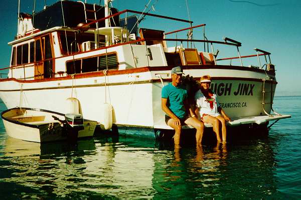
And the Really, Really Good News
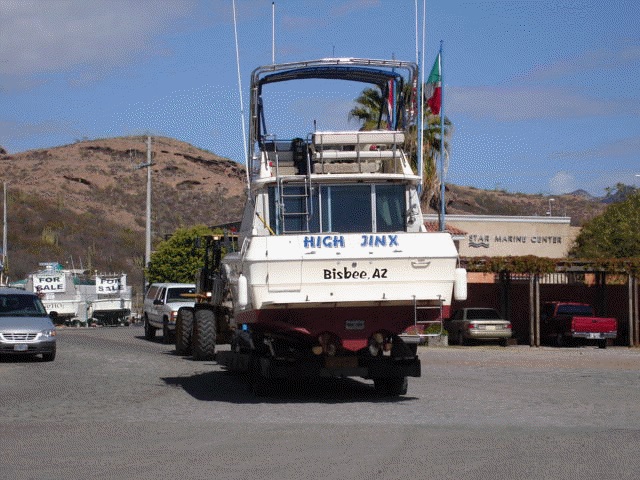
The New High Jinx
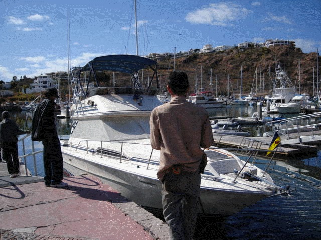
Ahhhhh! That’s better.
With the kind permission of Bill Parlatore, the editor of PassageMaker Magazine, we are reprinting our article in the Winter 1996 issue of that fine magazine. We have made a few updates. Here goes.
Gunkholing along the Baja in the Southern Sea of Cortèz
by Jinx and Mad Dog Schwartz
A Little History
In 1539 the Spanish conquistador/explorer, Hernàn Cortès, dispatched a fleet of his ships from the Mexican mainland to sail northward until they ran out of water, or found a passage around the “island” he knew was to the west. His armada returned with the disappointing news that the “island” they sought to circumvent was, in fact, a peninsula. Cortès considered the peninsula a worthless piece of desert with no fresh water or (more importantly) gold, so he dismissed the land, but named the body of water for himself: Mar de Cortès.
In 1847, the United States of America, after being granted Baja California as part of the settlement at the end of the Mexican-American War, considered it a worthless piece of desert and promptly gave it back! For that oversight, we can be eternally grateful, for had we kept this arid peninsula, it would surely be as paved-over, built-up and polluted as Alta California. And the Sea of Cortèz would most certainly not be as pristine and abundant with wild life as it is today.
The solitary and haunting volcanic beauty of the Sea has remained relatively untouched over the past four and one half centuries since its discovery by Cortès, and is surely one of the most picturesque bodies of water in the world.
Boating on the Moon
Many a cruiser has likened the Sea of Cortèz, or the Gulf of California as it is also called, to a moonscape. There is little doubt of the origin of the islands, as they are frozen in time: you can almost picture the rugged cliffs being suddenly cooled to form their honeycombed appearance or envision the huge boulders being flung about by volcanic blasts. Cactus and elephant trees dot the rock formations which rise dramatically from the turquoise Sea. The overall effect is surreal, taking you backwards through time, to when the earth split and the rift flooded with water to form this beautiful gulf.
As seas go, the Sea of Cortez is not a very large one, and is defined on the east by the Mexican mainland and on the west by the Baja Peninsula. We have yet to see a chart which shows the exact coordinates of the southern boundary, but the Mexicans tell us that by drawing a straight line between Cabo San Lucas and Mazatlan, everything north is considered the Sea. Charted in the late 1800’s, and not updated since, you have to rely on various cruising guides with GPS coordinates to accurately navigate this body of water, but we did just fine, thank you, for five years using the old charts and some common sense. It also helps that the visibility in this part of the world is excellent and there are few reefs!
Why the Baja Side?
On the mainland side of the Sea, there are few weather-safe anchorages, other than at the ports of Mazatlan and Topolobampo, until you reach the Guaymas/San Carlos area. For this reason, most cruising yachts, when transiting the sea, will cross over from Mazatlan to the Baja, and then cruise along the peninsula as they gunkhole north. There is no practical reason for not getting out in the middle and heading north, but why do that? A cruising couple could spend years exploring both sides of the Sea and never stop discovering new, interesting places to visit. Many cruisers who pushed on to the Panama Canal and Caribbean, or the Pacific Ocean and the south seas, have returned to the Sea of Cortez to tell us these waters are the best overall cruising they experienced.
This is trawler territory. Although we are out-numbered fifty to one by sailboats, a trawler is actually better suited for full time cruising in these waters. The bay-like configuration of the Sea makes for relatively serene waters, and most sailors complain that there is either no wind or too much wind. It is a local joke that the sails on most vessels are great, especially when lowered in order for a shade canopy to be attached to the boom.
Make no mistake though, weather conditions in the Sea can capture your attention. While the seas are generally flat (0-2 ft), with no swell, the wind does pick up and waves can quickly build to four feet or more. And they are square! A trawler’s heft is mighty welcome in riding out these confused humped-up blocks of water that come at you from three directions at once.
Tidal currents run from a benign one or two knots at the south end of the Sea, with a tidal range of one or two feet, to more than six knots at the northern extremities, with a twenty foot swing! When anchoring in the extreme northern part of the Sea, great caution must reign, unless an impromptu bottom-cleaning is on your agenda.
Fishing
For those interested in big game fishing, the same line that defines the southern boundary of the sea is also roughly where the prize winning billfish are snagged. For the rest of us, dorado (mahi-mahi), yellowtail, yellowfin tuna, sea bass, snapper and innumerable yummy fish abound throughout the Sea for our dining pleasure. We seldom bottom fish for dinner except on the day we intend to eat it…leaving our freezer space for beef and chicken! We do, however, drag a lure almost every time we get underway…just in case! Please keep in mind that it illegal for a cruiser to capture any type of shellfish.
Getting There
Just the fact that you have arrived in the Sea of Cortèz means that you have accomplished a major navigational feat. From San Diego, you have traveled in the Pacific Ocean along the barren 1000 miles of Baja shoreline to Cabo San Lucas. After finding only one well-protected provisioning and fueling anchorage (Turtle Bay) available along those long, lonely miles, many cruisers are somewhat dazed by the glitzy, full service atmosphere at Cabo San Lucas. Or perhaps you have arrived via the Panama Canal, and have enjoyed the Mexican Riviera on your way north. Whatever route you have taken, when you reach the Sea of Cortèz, you will soon face a whole new set of problems and opportunities.
Leaving Cabo San Lucas, the next protected anchorage on your way around the east cape is a day’s run to Los Frailes-a great spot unless a southerly is blowing. The beach is dotted with campers, a few houses, and even a restaurant that occasionally gets wiped out by a storm. As in all of the Baja, small stores and palapa-roofed restaurants come and go, so don’t plan to eat out a lot unless you are near a large town. Frailes is also a stopover for cruisers traversing the Sea from Mazatlan and Puerto Vallarta, and is basically considered a jump-off point rather than a long-term anchorage. Some vessels, however, have spent quite a bit more time at Frailes than planned while taking refuge from the strong northerlies. Don’t even THINK about leaving Cabo San Lucas without full fuel tanks and adequate provisions. Although La Paz is, at a glance on the chart, only a two-day trip from Cabo, weather can delay you for much longer.
Rounding the east cape, crossing the Tropic of Cancer, and heading up into the Sea, you’ll probably want to stop over at Bahia de los Muertos for the night. As at Frailes, the beach is dotted with campers. In a pinch, one of them might give you a ride back to Los Barriles for some supplies. Both Los Barriles and Rancho Buena Vista have small stores, but the open roadstead here can turn nasty at the drop of a centavo. It is not by accident that the area around Los Barriles claims to be the wind-surfing capitol of the world!
Keeping Isla Cerralvo to starboard, continue north through the Cerralvo Channel until making your turn into the Lorenzo Channel, between the peninsula and Isla Espiritu Santo. There is a large channel marker that you must keep to port when you are in the Lorenzo, but if you are worried-as we were the first time-just slow down and watch the water for signs of the visible reef that stretches from the beach on the peninsula to the marker. We have seen many vessels cut the corner, but until you gain some local knowledge, let caution be your guide.
The channel leading into the town of La Paz is first spotted from afar by a plume of smoke rising from the Pemex Refinery at the entrance. Stay close to that facility until you spy the first channel marker. Once in the channel, you are well advised to stay in the center-as wandering about will surely put you aground. Turn your VHF to channel 22 (the cruiser’s channel), tell your fellow yachtsman that you are on your way in, and you’ll get all the good advice you can stand! The Marinas monitor channel 16.
La Paz is an old colonial town and sea port that until very recently had dirt roads on all except the main streets. During the past six or seven years, this charming Capitol of Baja California Sur has experienced a mini-boom of paving and services. Before continuing your trip into the Sea of Cortez, La Paz is a “must stop” port for provisioning and getting acquainted with fellow cruisers. Gringo (American) grocery items are readily available in modern supermarkets, but we have found many Mexican products are much better. Cellular phone service has made the scene and a plethora of services, scarce only a short time ago, are now available to cruisers.
Thankfully, with all of this progress, La Paz is still a delightfully Mexican town in which the people go out of their way to make you feel welcome. Don’t expect the touristy atmosphere of the Mexican mainland towns or Cabo San Lucas, and do not be surprised that most of the residents do not speak English.
There are three major marinas in La Paz, each with its own distinct personality. Our favorite is Marina de la Paz, with Mac and Mary Schroyer at the helm. Mac and Mary have been in La Paz since slightly before Cortez showed up, and are a godsend to the cruising community. Mary is the harbormaster and offers 110/220, water, cable TV, chandlery, restaurant, laundry, showers, phone, fax, diesel, and, in our opinion, the best mechanic in town, Joel. Mary will lend a helping hand to get you through some of the more confusing aspects of having a boat in Mexico. As a berther in Marina de La Paz, you can, for a reasonable fee, check in and out of port without fending your way along the long and winding trail through the various authorities. If Mary’s 80 slips are booked up, as they are frequently during November through January and in the spring, dinghy to her dock to get information and help. Club Cruceros de La Paz, the local yachting organization, maintains a club hut on the premises that offers incoming mail service and a book exchange, as well as being the unofficial information center for anyone who wants to know more about the Sea of Cortez.
Marina Palmira is the newest and most modern of the marinas, but is a bit away from the central district and has fairly spendy day rates compared to the other marinas. It is a beautiful full-service facility with 140 slips, up to 100’, and they even offer dry storage for large vessels up to 55 feet and forty tons.
Marina Don Jose Abaroa is always chock-a-block with resident cruisers, and seems to appeal more to those cruisers that want to stay awhile, but don’t want to anchor out. The Abaroa family owns and operates this marina, which offers haulout facilities on the
premises.
Should you opt to anchor out at La Paz, there is abundant room. There is, however, one drawback, called the “La Paz Waltz,” The waltz is the result of opposing tides and winds that set you broadside to enough chop to make for an uncomfortable few hours. Then you will swing widely at slack, only to be set broadside again when the wind changes. Your best bet before anchoring is to talk to your fellow anchor-outs before you drop the hook, because they know which way and how far they will arc on their swing.
Be sure to take full advantage of all of the services offered in La Paz. Stock up on any and everything you can possibly think of, for when you leave to go north, you will be glad you did.
The Islands
Leaving La Paz behind, most cruisers head north for Isla Espiritu Santo. There are other anchorage’s on the peninsula to check out on your way to Espiritu Santo, namely Pichilingue, Lobos and Ballandra. These spots are fine for stopping over to see, but Pichilingue, the only “hurricane hole” in the area, has a busy dock for the ferries from the mainland. Why anchor there when so many other places are better? Lobos is a small anchorage favored by some, and can only accommodate a few boats, but is worth checking out. Ballandra is a nice anchorage, but getting caught there in a northerly can be devastating: more than one vessel has hit the beach here.
Isla Espiritu Santo is where you will get your first taste of what we call the Sea of Cortèz experience. It is here that you begin to feel that sense of solitude that is so special to the Sea. There are many unfrequented anchorage’s around this island, with comfort levels that are weather-dependent. The general rule of thumb is to look for northerlies from November until May, and southerlies from June through October. As anyone who has tried to forecast the weather in the Sea can tell you, just about anything can happen at any time…and will: Cabo San Lucas, at the tip of the Baja, was laid waste by a rare winter storm from the south in December of 1982.
Before telling you about our favorite spots along the southern Baja and in the Sea, let us first tell you what is available in the way of services on the islands: zero…zip…nada. Once you leave La Paz, the next reliable place to get gasoline, diesel fuel (jerry jugged from twenty miles away), water, and groceries, is 118 miles north, at Puerto Escondido. On the islands there is no water, and there are no permanent structures. You will see a few temporary shelters used by local fisherman, but that is all: you must bring everything with you. And please, take away everything you brought!
Eons ago, the north end of Isla Espiritu Santo erupted, and the resulting crater filled in to create a dramatic anchorage. Isla Partida, the island formed to the north, and Isla Espiritu Santo are connected by a sand bar with a channel that is navigable by dingy at high tide. The well-protected anchorage at Partida, as it is called, merits a long stay. We have safely ridden out a fifty-knot norther here, and have also tucked up into the northwest corner to hide from some strong southerlies. Snorkeling and diving is a dream around the island, and we usually take our dingy to the dive spots that abound.
On the north end of the island is a small group of rock islands, Los Islotes, where you can swim with some amicable seals.
We have, at one time or another, anchored in every wedge big enough to accommodate the High Jinx, and you will soon find your favorite. One thing to remember, though, is unless you are in Partida, you may have to move there because of a wind change. Familiarize yourself with the reef at the north side of the entrance to Partida and save yourself some anxious moments in the middle of the night! There are few beacons marking hazards to navigation in the Sea of Cortez, and until you gain some local knowledge, cruising around at night is not a good idea.
The local pescaderos at the islands stay pretty much to themselves, but if you want some fresh fish, they are friendly and willing to trade fish for a few pesos, a can of spam, or even a baseball cap. Once in a while they will ask for some water, and we are more than glad to share ours.
Isla San Francisco, north of Espiritu Santo, is perhaps our favorite island in the entire Sea of Cortez. Perhaps it is because we feel so comfortable snorkeling in the pristine anchorage formed by a sparkling sand beach. The sand bottom of the cove is home to thousands of garden eels, and it is a constant delight to watch them sink into the sand when you float over them. There are two or three resident panamic moray eels, bright green and very large that are sure to give the snorkeler pause for thought-and are a bit too friendly for some divers. One of our friends literally climbed his anchor chain when one of the nosey eels followed him home.
As in Eden, there is a “serpent” in this garden…and it isn’t an eel. No, this pest is so tiny that most cannot see them, and only discover their existence 24 hours after a visit when itchy red spots abound. Microgram for microgram, the little jejene, also known as a no-see-um, packs a bite than can you sick, as well as uncomfortable. The little devils hatch here in late spring and stay through the summer. Every bite is pure torture, and can last for weeks. The best cure is prevention (don’t go near the beach at night), but if you are bitten, we have found the best relief is to take an antihistamine and rub Preparation H on the bites. Please spare us the puns here…it works!
San Francisco Island’s crescent shaped anchorage provides protection from most directions, if you are willing to move around. The worst thing is to be caught by a westerly while anchored in the middle. The southern anchorage shallows up rapidly and can get crowded if several boats want to hide from a Coromuel. Coromuels are spring and summer southerly winds that cool La Paz and sometimes cause problems for unprepared cruisers. The good news is that they are predictable: so predictable that Cromwell’s pirates, for whom the wind is named, used the afternoon blow to make his escapes after a day of plunder and pillage.
A great day trip from San Francisco Island is to a tiny rock at the north end called Isla Lobo. It is the only legally inhabited island in the Sea, and generations of the same family have lived and fished here for over one hundred years. Anchoring in the aquarium-like cove there overnight is an iffy proposition, and we have always opted to return to San Francisco Island for the night. Be sure to dingy over to Roca Foca (Seal Rock) nearby to visit the inhabitants.
Isla San Jose is just north of Lobos, boasts a lagoon to visit by dingy, and affords protection from the south. The problem here is that when the southerlies are blowing it is usually no-see-um season, and when the northerlies are blowing it is unprotected. To get a good night’s sleep, it might be wise to move on to San Everisto, eight miles northwest on the peninsula across the San Jose Channel. Drag a lure on the way, for the channel is well known for fish…especially dorado.
The tiny village of San Everisto has a well-protected anchorage, and even a small tienda (store) where a few very basic items can be purchased. Forty-five bone-jarring miles of rock road connect this salt-producing village to the main road, and in an emergency you can get a ride in an antiquated truck loaded with salt. The water supply from a well here is brackish, causing the inhabitants to truck in drinking water. Chances are that you will be asked for water here, rather than being able to obtain it! Check out the beaches outside the entrance (which does have a light tower) for Lion’s Paw scallop shells.
Leaving Everisto behind, you have the option to stop over at Nopolo and Puerto Gato along the peninsula, but both are weather dependent. At the islands of San Diego, Santa Cruz, and Catalina, we found no secure anchorages. The next all-weather anchorage is at Agua Verde, forty-eight miles north. Nopolo and Gato are enjoyable but we have been chased out by weather. As any seasoned cruiser knows, we sometimes opt to enjoy a less-than-perfect anchorage…and if we just stuck to the safest spots we would miss a great deal. This is especially true of the Sea of Cortez. Because so much depends on weather and local knowledge here, we need to halt our cruise northward to discuss the most important method for staying abreast of these important topics: Amateur (ham) Radio.
Communications
The Baja peninsula and the Sea of Cortez are amongst the most remote, and for the most part, uninhabited areas in North America. For this reason, reliable, effective communication is a significant factor to consider in your cruising plans. There is no substitute for ham radio in the Sea of Cortez, whether it be audio or pactor (email).
“Oh, no!” you say, “I can’t possibly learn all of that Morse Code and technical stuff to get a ham license!” But you are wrong, for there is good news! All you need is a No-Code Technical license and a Mexican provisional permit. This will allow you to legally talk on all ham frequencies, as long as you are in Mexico or in Mexican waters. The no-code test is easy, so do yourself this big favor and get your license. You will be glad you did!
In addition to tuning in to various cruiser nets (broadcasts) for local weather, weather forecasts, message handling, and chats with other cruisers, you can get phone patches to the United States through helpful and cheerful stateside ham operators. There will be times when an emergency exists, or you want to contact your family and friends back home, and this is, hands down, your best bet. It is a long way between phones in the Sea of Cortez! Of course, you can use the High Seas Operator, but why throw money away…and the operator can’t tell you which way the wind is blowing.
There are several nets that aid cruisers in Mexican waters. The most popular ones are as follows:
- Sonrisa Net 3968KHZ Daily 1430Z Local Weather/Chat
- Chubasco Net 7294KHZ Daily 1545Z Weather forecast/phone patches
- Baja Net 7238.5 KHZ Daily 1600Z Weather/phone patches
- Mañana Net 14340 KHZ Mon-Sat 1900Z Weather/phone patches
- Happy Hour 3978 KHZ Daily 0000Z Cruiser Chat
Your marine single sideband or ham radio is one of the most important pieces of equipment on your vessel. A full time cruiser is likely to visit many remote areas where there are no other vessels or inhabitants within range of your marine VHF radio. Your ham rig will be your only means of communications to the outside world and your safety net should you get in trouble. A vessel in distress in the Sea of Cortèz is almost always aided by fellow cruisers. We have seen only one Mexican Coast Guard Vessel in the Sea, and in every instance known to us over the years, ham radio was indispensable in aiding rescues. The Mexican Navy is slow to respond, not because they don’t care, but because they have few ships, which are dispersed widely throughout Mexico. Now that you have that license, we are free to proceed.
Agua Verde is a favorite cruiser hangout, although north anchorage is small. Unless there is room for you in the extreme northeast corner of that anchorage during a norther, the surge can rock you…and not to sleep! But never mind, you’ll be safe, and when you take a walk into the village you will find a small tienda that sporadically has a few veggies and canned goods, and a place to get a taco or two. Agua Verde is a great spot to trade for fish or, if you are a diver, spear your own red snapper. There is a reef that bears watching near the entrance, but it does have a light on it.
Leaving Agua Verde, you have two routes to choose from on your way to Puerto Escondido and both are delightful, but the inner passage, leaving Isla Danzante to starboard, is the most protected. Isla Montserrat is a good summer stopover, and is the site of the yearly crab races, an informal cruiser event. The best anchorage is at the northern end, but should be avoided during the winter (norther) months.
Isla Danzante’s Honeymoon Cove is one of our favorites, but there is only room for one boat in this tiny wedge. Once we were entertained every morning for a week by a sea turtle that found some gormet delight clinging to our anchor chain. The rock walls seem really close, and you don’t want to get caught here in a southerly. During a norther we put out a stern hook to check our swing. If you feel at all threatened, move a few yards to the south to a roomier spot. Look out for no-see-ums in the summer.
Running out of almost everything? It’s time to leave Danzante and cross back to the Baja Peninsula, and Puerto Escondido. Although the tour books refer to a marina at Puerto Escondido, there is none. At one time there were some docks, but they were washed away by a storm and never rebuilt. During the past few years, development schemes have abounded, but all came to naught. The only thing that happened is that a lovely bird habitat was dredged up, some canals built, and that was that.
The group that owns the seawall and property generously provide the cruiser with a place to fill your tanks (stern tie to the wall) with great tasting-and safe to drink-mountain water, as well as garbage service*. Many cruisers live here year round and have vehicles that the owners of the “marina” allow to be parked on their lot. There is usually a taxi hanging around to see if anyone needs a ride into Loreto, twenty miles away. And you will, if you go ashore here, have to go to Loreto to check in with the Port Captain. Get on the radio (try VHF22 or 68 or 16) and ask your fellow cruisers what the drill of the day is with the local authorities, and what time the VHF cruiser’s net will be broadcast.
Not only cruisers live here; there is a large trailer park (Tripui) within walking distance, where there is fax and phone service, as well as a grocery store and a restaurant. The bar in the restaurant has cable, and cruisers and park residents alike turn out to watch American football games in the fall and winter. There is even a Yacht Club to join-Hidden Harbor-that sponsers social and charitable activities.
During your stay at Puerto Escondido, be sure to stock up on supplies, take in a little homestyle social life, fill your tanks and get ready to head north to more islands, anchorages and adventures in the Central Sea of Cortez
Update: You now must pay ten pesos a week for dumping garbage. twenty bucks to park and you have to pay for water, but it is all a bargain. Also, laundry is done at the tienda–wash, dry and fold for 40 pesos. Another bargain. And, thanks to the Hidden Port Yacht Club, there is a really nice new dinghy dock. Thanks, guys and gals.
Some recommended guides for Baja and the Sea of Cortez:
- “Boating Guide to Mexico” by John Raines & Pat Miller
- “Charlie’s Charts” by Charles E. Wood
- “Chart Guide – Mexico West”
- “Gerry Cunningham’s Cruising Guides, Tide Tables & Light Lists to the Sea of Cortez” by Gerry Cunningham
- A good Spanish Dictionary
A few recommendantions for equipment to make life more comfortable and safe:
Baja Fuel Filter: A funnel device with several filters used at the fill location on deck. We use it only when at remote fuel sites, when filling up from 55 gallon drums. We have never gotten bad diesel from a fuel dock in the Sea.
Bread Machine: Bimbo is the bread of Baja and will keep for weeks, but is not to our liking. We use Mexican flour in our bread machine, and although it is a little light in gluten, it serves the purpose. Mexican yeast is excellent.
Shade and screens: Very important items…you cannot have too many!
Solar Panels: One thing we have plenty of is sun, so save your fuel and wear and tear on your generator.
The biggest dinghy and motor you can haul and afford. We have gone to a hard dinghy (a small panga manufactured in La Paz) after two inflatables collapsed in the intense Baja sun. If you do have an inflatable, make a cover.
Watermaker: What can I say, you are boating in a desert!
Refrigeration: You simply cannot have too much. We added an ac/dc/propane freezer unit to our flying bridge.
And lots of: reading material, U.S. stamps (so gringos can take mail back for you), paper products (expensive in Baja), canned goods, and fishing tackle.
For more information on the Sea of Cortez and Baja California, link to any listed below.
- Weather and fishing information.
- Great site for Baja cruising updates and the latest in La Paz: Baja Insider http://www.bajainsider.com
- Mexico General Info
- Lots of good fishing info
- Casa de Amigos Real Estate: Rentals and Real Estate in San Carlos
- Cruising the Sea of Cortez
- Marina Real, San Carlos
- Baja Destinations: Good info by very knowledgeable folks
- Discover Baja: Fishing licenses, boat and car insurance, lotsa good stuff.
- Mexican Insurance through www.mexacan.com
- Club Cruceros – La Paz
- News of Baja
2003’s disasters in the Sea of Cortez
This is one cruise we’re glad we missed. A picture of the height of the storm in Puerto
Escondido harbor
Mary Shroyer sent us this aerial view of what’s left of her marina.
You cannot have too many books on board; here are some must-haves.
- GENE KIRA’S King of the Moon: it’s just flat wonderful. Gene has captured the very essence of a time that is fast disappearing in the Sea of Cortez.
- Graham McIntosh’s books featuring his burro-assisted treks though the Baja are as entertaining as they are informative.
- Troubled Sea, by me, of course. See top of site for info.
- Just Add Water, also by me. It’s not about the Sea of Cortez, but it is about boating and it is funny.
Get ’em all at La Tienda in Mulege.
2004/2005 Marina News
They are all pricey!!!
Marina Real: sustained some damage in Marty, but not much. They have dry storage, as well as a fuel dock, and showers. Also, the RV park above the marina has a laundry and restaurant. Dario reports that courtesy shuttle to San Carlos runs several days a week. This is really good news for you cruisers without cars.
Marina de la Paz: http://www.marinadelapaz.com/ Marina de la Paz is, in our opinion, the only place to stay in La Paz. Or will be. when rebuilt! Okay, we’re biased, but this is our website!!
Marina San Carlos: They raised their rates 15% and installed security gates in 2003. No damage from Hurricane Marty.
Marina Santa Rosalia: Rumor has it there may be a fuel dock someday, but don’t hold your breath. It’s still the cheapest Marina in the Sea.
- Great site for Baja cruising updates and the latest in La Paz: Baja Insider http://www.bajainsider.com
- New! Visiting Ensenada? Check out The Land and Sea Guide to Ensenada: True Traveler Publishing
- Mexico General Info
- Lots of good fishing info
- Marina Real, San Carlos
- Baja Destinations: Good info by very knowledgeable folks
- Discover Baja: Fishing licenses, boat and car insurance, lotsa good stuff.
- Mexican Insurance through www.mexacan.com
- Club Cruceros – La Paz
- News of Baja
- Downwind Marine